Foxtech Provides Industrial Drone Solutions & UAV Payload Systems.
FOXTECH HOBBY CO.,LIMITED promotes best indoor drone with scientific and professional production process in the global market. It is at the leading level of the industry with standard the 5S operating environment, which is the guarantee of product quality. It features with scientific structure and aesthetic appearance. High-performance materials are bound to highlight the value of this product. Finest techniques ensure the accuracy of specifications, making it more convenient to apply.
Foxtech has done a great job in achieving high customer satisfaction and greater industry recognition. Our products, with the increasing brand awareness in the global market, help our clients create high levels of economic value. According to customer feedback and our market investigation, our products are well-received among consumers for the high quality and the affordable price. Our brand also sets new standards of excellence in the industry.
We have built a strong customer service team - a team of professionals with the right skills. We organize training sessions for them to improve their skills such as excellent communication skills. Thus we are able to convey what we mean in a positive way to customers and provide them with the required products at Foxtech in an efficient manner.
The 2025 World Drone Congress has just concluded, gathering top global enterprises, research institutions, and industry leaders. Drones are being applied across a wide range of fields, covering almost every sector.
Drones are evolving from “tools” to “intelligent ecosystems”
Penetrating All Industries
In the next five years,
With technological breakthroughs and improved policies,
Drones will reshape our lifestyles.
Are you ready?
According to data from the Civil Aviation Administration of China, over 1.875 million drones were registered nationwide in the first half of 2025, a year-on-year increase of 48%. Driven by both market demand and technological advancements, drones are becoming central to the low-altitude economy, and multidimensional application scenarios are reshaping industrial ecosystems through an “aerial revolution.”
Development Trends in Civil Drones
From agricultural protection and logistics delivery to emergency rescue, security, and patrol, the application scenarios of civil drones are expanding at an unprecedented speed.
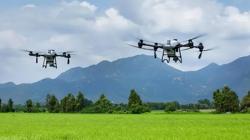
1. Agricultural Drones Advancing Toward “Full Automation”
In crop monitoring, drones equipped with sensors or cameras can monitor crop growth and detect pests and diseases in real time, assisting farmers in scientific field management. In plant protection, drones can carry pesticide tanks and spraying equipment to apply pesticides, fertilizers, or herbicides precisely, improving efficiency while reducing costs and labor.
Drone spraying ensures more uniform coverage of crops and enhances pest control effectiveness.
AI + precision agriculture enables drones equipped with multispectral sensors to monitor crop health in real time. Combined with AI algorithms, drones can automatically apply fertilizers and pesticides, increasing efficiency tenfold.
Drones can also be used for terrain mapping and land monitoring, providing reliable data for agricultural planning.
The agricultural drone market is expected to exceed USD 20 billion by 2030.
2. Logistics Drones Enter the “Minute-Level Delivery” Era
With many countries relaxing low-altitude flight restrictions, drones are being increasingly used in logistics, especially in remote or hard-to-reach areas. Drone logistics networks will enable fast and accurate delivery of small goods such as parcels and medicines, significantly improving logistics efficiency and reducing labor and vehicle costs.
Industry giants are racing to deploy: Amazon, JD.com, SF Express, and others are rapidly advancing drone delivery, with urban “15-minute delivery” expected by 2025.
3. Emergency Rescue Drones Become “Guardians of Life”
With the support of the drone technology ecosystem, China’s capabilities in disaster prevention, reduction, and relief have been significantly enhanced, enabling more efficient, safer, and smarter disaster management.
In complex terrains such as mountains, forests, and oceans, drones can search for missing persons and provide critical information to assist rescue operations.
Drones can also quickly deliver supplies and establish communication relays, playing a key role in disaster relief.
With rapid response to extreme weather and breakthroughs in swarm technology, multi-drone collaborative operations can achieve large-area search and rescue.
4. Security and Patrol
Drones can be used to patrol borderlines, detect intruders or suspicious activities, and ensure national security.
They can also monitor urban traffic and public safety in real time, providing strong support for city safety management.
Equipped with HD cameras and positioning systems, drones can autonomously patrol power grids, detect safety hazards, and transmit images in real time.
This greatly improves the efficiency and safety of power inspections, reducing injuries and power outages.
5. Environmental Monitoring and Protection
Drones, equipped with onboard sensors and high-definition cameras, can monitor environmental parameters such as air, water quality, and soil in real time, collecting high-resolution images and video data.
They can also locate and monitor pollution sources, providing accurate data to environmental authorities and supporting pollution control efforts.
6. Scientific Research and Education
– Scientific Research: Drones have wide applications in research fields such as atmospheric and ocean exploration, geological surveys, and archaeological excavations, enabling efficient data collection and sample retrieval.
– Aerial Education: In education, drones can be used for aerial teaching, such as geological fieldwork and natural landscape education.
HD images and video captured by drones allow students to intuitively understand natural phenomena and laws.
7. Other Civil Applications
– Sports Events: Drones can be used for live broadcasting and filming of sports events, enhancing the viewing experience.
– Advertising & Promotion: Drones can be used for aerial advertising and event shooting in promotional campaigns.
– Entertainment & Leisure: Drones are widely used in entertainment, such as model aircraft competitions and aerial shows.
– Building Inspection: Drones can inspect buildings, bridges, and other infrastructure, improving work efficiency and safety.
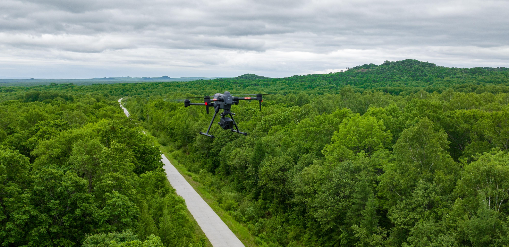
– Aerial Photography & Filmmaking: Drones have a unique advantage in aerial photography, providing aerial images and footage for urban planning, land surveys, disaster assessment, tourism promotion, and the film/TV industry.
The International Civil Aviation Organization (ICAO) is promoting the development of drone air traffic management systems. With regulatory and technical upgrades progressing in parallel, safety has become a core concern. Anti-collision and countermeasure technologies are advancing rapidly.
Balancing innovation and regulation will remain a long-term issue for the industry.
As companies like EHang and XPeng accelerate the commercialization of passenger drones, cities like Dubai and Shenzhen have already launched pilot programs.
Urban Air Mobility (UAM) is moving from concept to reality, and over the next five years, UAM could give rise to a trillion-yuan market.
Drone Mapping Operations
Drone image stitching software Photoscan (software installation, cracking, localization, etc.)
Detailed explanation of software interface and functions (menu bar, toolbar, workspace, model interface, etc.)
Basic software operation learning and practice (image loading, visualization, preprocessing, etc.)
Introduction to different image stitching modes (individual 3D modeling, orthophoto aerial mapping, etc.)
General process of image stitching (image alignment, point cloud generation, point cloud editing, orthophoto, digital elevation model, etc.)
Batch processing implementation of image stitching workflow (writing and saving batch processing files, etc.)
Image group stitching and merging (image grouping, different chunks, chunk alignment, chunk merging, etc.)
Geometric correction of images using ground control points (planning of control point layout, control point measurement, image geometric correction, etc.)
Point cloud classification operations and practice (automatic classification, manual classification, etc.)
Visualization of image stitching results (orthophoto, digital elevation model, contour lines, etc.)
Geometric measurement of image stitching results (point coordinates, length, area, volume, etc.)
Exporting image stitching results (JPG format, TIFF format, Google Earth format, etc.)
Generation of project report for image stitching workflow (report interpretation)
Advantages of Drone Technology
High Precision: Drone aerial survey technology uses high-resolution cameras and multispectral sensors to obtain high-definition images and multi-band data of the surface, enabling high-precision mapping and investigation.
High Efficiency: Drone aerial survey technology has the ability of quick response and efficient operation, allowing large-scale mapping and investigation tasks to be completed in a short time.
Low Cost: Compared with traditional surveying methods, drone aerial survey technology has lower costs. With the popularization of drones and other small aircraft, the equipment cost and operation threshold of aerial survey have been reduced.
Flexibility: Drone aerial survey technology is flexible and scalable, allowing customized design and application according to different task requirements.
Development Trends of Drones
Intelligentization: With the continuous development of artificial intelligence technology, drone mapping will achieve more intelligent data acquisition and processing. Through machine learning and deep learning algorithms, drones will be able to autonomously judge and optimize mapping paths, improving the accuracy and value of data.
Integration: Future drone mapping systems will be more integrated, combining multiple sensors and devices on the drone platform to achieve synchronous acquisition and processing of multi-source data.
Real-time Capability: With the development of 5G, cloud computing, and other technologies, the data transmission and processing of drone mapping will become more real-time. Users can obtain mapping results in real time for decision analysis.
Standardization: With the popularization of drone mapping technology and the expansion of its application fields, relevant standards and specifications will be further improved. This will help standardize the application and management of drone mapping technology and improve the quality and reliability of mapping results.
As drones become increasingly popular in surveying applications, the demand for high-quality drone mapping cameras continues to rise. These specialized cameras play a crucial role in capturing accurate aerial imagery for mapping, construction, agriculture, and various other industries. But what exactly makes a drone mapping camera ideal for surveying purposes? In this article, we will explore the key features and characteristics that define a top-tier drone mapping camera.
High Resolution and Image Quality
One of the most important factors to consider when selecting a drone mapping camera for surveying is its resolution and image quality. High-resolution cameras are essential for capturing detailed and accurate imagery of the landscape below. The higher the resolution of the camera, the more information it can capture, allowing for more precise mapping and analysis. In addition to resolution, image quality is also crucial, as clear and sharp images are necessary for creating accurate maps and models. Look for a drone mapping camera that offers at least 20 megapixels or higher resolution to ensure optimal results.
Global Shutter Technology
When it comes to capturing images from a moving drone, global shutter technology is a game-changer. Unlike rolling shutter cameras, which capture images by scanning each line sequentially, global shutter cameras capture the entire image at once. This eliminates motion blur and distortion, ensuring that the images captured by the drone mapping camera are sharp and accurate. Global shutter technology is particularly important for surveying applications, where precise image capture is essential for creating detailed maps and models.
Geotagging and GPS Accuracy
Accurate geotagging is essential for georeferencing aerial images and creating precise maps. A high-quality drone mapping camera should have built-in GPS technology that accurately tags each image with its geographical coordinates. This allows surveyors to easily integrate the images into mapping software and align them with other geographic data. Look for a drone mapping camera with dual-frequency GPS for enhanced accuracy, especially in areas with poor satellite reception. Additionally, the camera should support real-time kinematic (RTK) positioning for even higher levels of precision.
Radiometric Capabilities
Radiometric capabilities are essential for capturing accurate and consistent data in various lighting conditions. A drone mapping camera with radiometric capabilities can adjust the exposure settings for each pixel individually, ensuring that all parts of the image are properly exposed. This is crucial for creating maps and models with consistent color and brightness, even in challenging lighting conditions. Radiometric cameras also allow for more precise analysis of vegetation health, moisture levels, and other key indicators for agricultural and environmental applications. Look for a drone mapping camera that offers radiometric capabilities for optimal results in surveying projects.
Compact and Lightweight Design
When it comes to drone mapping cameras, size and weight matter. A compact and lightweight camera is essential for ensuring that the drone can carry it efficiently and capture images without compromising flight stability. Look for a drone mapping camera that is specifically designed for aerial surveying and is lightweight enough to be mounted on a variety of drone models. Additionally, consider the overall size of the camera, as smaller cameras are less likely to obstruct the drone's field of view and can capture images from multiple angles more easily. A compact and lightweight design will make your drone mapping camera more versatile and capable of handling a wide range of surveying tasks.
In conclusion, a drone mapping camera ideal for surveying should possess high resolution and image quality, global shutter technology, accurate geotagging and GPS capabilities, radiometric capabilities, and a compact and lightweight design. By selecting a drone mapping camera with these key features, you can ensure that your surveying projects are accurate, efficient, and successful. Whether you are mapping construction sites, monitoring agricultural fields, or conducting environmental surveys, investing in a high-quality drone mapping camera is essential for obtaining reliable and actionable data. Choose a camera that meets your specific needs and requirements, and start capturing stunning aerial imagery for your surveying projects today.
Drones have revolutionized various industries by offering versatile solutions for aerial imaging and mapping. One of the most intriguing applications of drones is terrain mapping, especially for creating accurate 3D models of landscapes. The ability to capture detailed topographical data from the air has significant implications for industries such as surveying, construction, agriculture, and environmental monitoring. In this article, we will delve into the capabilities of terrain mapping drones and explore the accuracy of the 3D models they can create.
Understanding Terrain Mapping Drones
Terrain mapping drones, also known as UAVs (unmanned aerial vehicles) or UAS (unmanned aerial systems), are equipped with specialized sensors and cameras that can capture high-resolution imagery of the earth's surface from different altitudes. These drones are typically operated remotely by a pilot or autonomously using pre-defined flight paths. The collected data is then processed using photogrammetry software to create detailed 3D models of the terrain.
Terrain mapping drones come in various sizes and configurations, ranging from small quadcopters to large fixed-wing aircraft. The choice of drone depends on the specific requirements of the mapping project, such as the area to be covered, the level of detail needed, and environmental conditions. Some drones are designed for quick deployment and easy maneuverability in confined spaces, while others are optimized for long-endurance flights over large areas.
The key components of a terrain mapping drone include a GPS receiver for navigation, an inertial measurement unit (IMU) for stabilizing the aircraft during flight, and a camera or sensor payload for capturing images or other data. Advanced drones may also feature lidar (light detection and ranging) sensors for collecting precise elevation data or multispectral cameras for analyzing vegetation health. These sensors work together to collect accurate and comprehensive information about the terrain, which is essential for creating detailed 3D models.
The Process of Creating 3D Models
Creating 3D models using terrain mapping drones involves several steps, starting with mission planning and drone deployment. The pilot or operator selects the area to be mapped, defines the flight parameters, and sets up the drone for takeoff. Once in the air, the drone follows a pre-programmed flight path while capturing images or data at regular intervals. The collected data is geotagged with GPS coordinates to ensure accurate positioning in the final model.
After the flight mission is completed, the data is downloaded and processed using photogrammetry software. Photogrammetry is a technique that uses overlapping images to reconstruct 3D models of objects or landscapes. The software analyzes the images, identifies common points or features, and calculates the spatial relationships between them to create a detailed 3D representation of the terrain.
The accuracy of the 3D model depends on several factors, including the quality of the drone imagery, the precision of the GPS data, and the processing algorithms used. Higher-resolution images with good overlap and alignment result in more detailed and accurate models. Similarly, accurate GPS positioning and calibration of the drone's sensors are crucial for ensuring the correct scale and orientation of the 3D model. The choice of photogrammetry software and processing parameters also plays a significant role in the final output.
Challenges in Generating Accurate 3D Models
While terrain mapping drones offer exciting possibilities for creating detailed 3D models, several challenges need to be addressed to ensure accuracy and reliability. One of the main challenges is the quality of the drone imagery, which can be affected by various factors such as camera resolution, lens distortion, lighting conditions, and image blur. Poor image quality can lead to inaccuracies in the 3D model, especially in areas with complex terrain or vegetation cover.
Another challenge is the presence of distortions in the terrain caused by factors like lens distortion, perspective errors, and ground control points. These distortions can affect the geometric accuracy of the 3D model and introduce errors in elevation or position. To mitigate these issues, terrain mapping drones often use ground control points (GCPs) or checkpoints to calibrate the model and improve its accuracy. GCPs are physical markers placed on the ground with known coordinates, which are used to reference and correct the drone imagery during processing.
Environmental factors such as weather conditions, wind, and terrain complexity can also impact the accuracy of terrain mapping drones. Strong winds or turbulent air can affect the stability of the drone during flight, leading to motion blur or poor image quality. Similarly, dense vegetation or steep slopes can obscure the terrain features and make it challenging to capture accurate data. Overcoming these challenges requires careful planning, optimal flight parameters, and advanced processing techniques to ensure the accuracy of the 3D model.
Applications of Terrain Mapping Drones
Terrain mapping drones have a wide range of applications across various industries, thanks to their ability to create detailed and accurate 3D models of the terrain. In the field of surveying and mapping, drones are used to collect topographical data for land development, infrastructure planning, and environmental assessment. The high-resolution imagery and elevation models generated by drones provide valuable insights for site analysis, volume calculations, and change detection over time.
In the construction industry, terrain mapping drones are employed for site planning, as-built documentation, and progress monitoring of construction projects. Drones can capture real-time images of construction sites, monitor earthwork activities, and generate 3D models for clash detection and design validation. This helps construction companies streamline workflows, improve safety, and reduce costs by identifying potential risks or errors early in the project.
Agriculture is another sector that benefits from the use of terrain mapping drones for crop monitoring, field analysis, and precision agriculture. Drones equipped with multispectral cameras can capture detailed images of crops, analyze vegetation health, and identify areas of stress or disease. This information helps farmers make informed decisions about irrigation, fertilization, and pest control, leading to increased yields and reduced environmental impact.
Environmental monitoring and conservation are also key areas where terrain mapping drones play a crucial role in assessing ecosystem health, monitoring wildlife habitats, and detecting changes in natural landscapes. Drones can capture detailed images of forests, wetlands, and coastal areas, allowing researchers to study biodiversity, track deforestation, and monitor the impact of climate change. By integrating drone data with GIS (geographic information systems) and remote sensing technologies, environmental scientists can gain valuable insights into environmental trends and inform conservation strategies.
The Future of Terrain Mapping Drones
As technology continues to advance, terrain mapping drones are poised to play an even more significant role in shaping the future of aerial imaging and mapping. The integration of artificial intelligence (AI) and machine learning algorithms into drone systems is enabling automatic processing of drone data, faster generation of 3D models, and real-time analytics for decision-making. AI-powered drones can analyze vast amounts of imagery, identify patterns or anomalies, and generate actionable insights for a wide range of applications.
Advancements in sensor technologies, such as lidar and hyperspectral imaging, are also enhancing the capabilities of terrain mapping drones to capture more detailed and accurate data. Lidar sensors, for example, can create high-resolution elevation models, detect terrain features, and measure distances with precision, making them ideal for mapping complex landscapes or infrastructure. Hyperspectral imaging sensors can capture data across multiple spectral bands, allowing for detailed analysis of vegetation health, soil composition, and water quality.
The increasing affordability and accessibility of drone technology are democratizing aerial mapping and enabling more businesses and organizations to leverage the benefits of terrain mapping drones. From small-scale enterprises to large corporations, drones are becoming essential tools for data collection, analysis, and visualization in a wide range of industries. With ongoing innovations in drone design, software development, and data analytics, the future looks bright for terrain mapping drones and their potential to revolutionize how we capture and analyze 3D models of the world around us.
In conclusion, terrain mapping drones have the potential to create accurate 3D models of landscapes, offering valuable insights for a variety of industries and applications. By leveraging the capabilities of drones, businesses, researchers, and government agencies can gain a deeper understanding of the terrain, make informed decisions, and drive innovation in fields such as surveying, construction, agriculture, and environmental monitoring. While there are challenges to overcome in generating accurate 3D models, the advancements in drone technology, sensor capabilities, and data processing methods are pushing the boundaries of what is possible with terrain mapping drones. As we look to the future, the role of drones in creating detailed and precise 3D models will continue to expand, revolutionizing how we visualize and interact with the world around us.
Drones have become increasingly popular over the past few years, not only among hobbyists but also among professionals in various industries. One of the key components of a drone is its camera, as it allows users to capture stunning aerial footage and images. While standard UAV cameras are suitable for basic photography and videography, drone pro cams offer a whole new level of functionality and quality. In this article, we will explore what sets a drone pro cam apart from standard UAV cameras.
Enhanced Image Quality and Resolution
One of the primary differences between a drone pro cam and a standard UAV camera is the image quality and resolution. Drone pro cams are equipped with high-quality sensors, lenses, and image processing technology, allowing them to capture crisp, clear images and videos with vibrant colors and sharp details. These cameras typically have higher resolutions, such as 4K or even 8K, which results in superior image quality compared to standard UAV cameras. Whether you are shooting for commercial purposes or simply want to capture stunning aerial shots, a drone pro cam will deliver professional-grade results.
Advanced Stability and Control
Another key feature that sets a drone pro cam apart from a standard UAV camera is its enhanced stability and control capabilities. Professional drones are equipped with advanced stabilization systems, such as gimbals and electronic image stabilization, which help eliminate camera shake and ensure smooth, steady footage even in windy conditions or during high-speed maneuvers. Additionally, drone pro cams offer greater control over camera settings, such as exposure, white balance, and focus, allowing users to fine-tune their shots and achieve the desired creative effect.
Extended Flight Time and Range
Drone pro cams are often paired with high-performance drones that offer extended flight time and range compared to standard UAV models. This allows users to cover larger areas, shoot for longer durations, and explore remote locations without having to worry about battery life or signal loss. Professional drones are also equipped with advanced obstacle avoidance systems and GPS technology, which provide a safer and more reliable flying experience. Whether you are shooting a film, conducting aerial inspections, or capturing a special event, a drone pro cam with an extended flight time and range will enable you to achieve your creative vision.
Professional-Grade Features and Accessories
When it comes to drone pro cams, the devil is in the details. These cameras are packed with professional-grade features and accessories that cater to the needs of professional photographers and videographers. From interchangeable lenses and filters to advanced shooting modes and post-processing capabilities, drone pro cams offer a wide range of tools that empower users to push the boundaries of creativity and achieve stunning results. In addition, professional drones often come with a variety of accessories, such as extra batteries, carrying cases, and remote controllers, that further enhance the user experience and make aerial photography and videography more accessible and enjoyable.
Integration with Professional Software and Workflows
Lastly, drone pro cams are designed to seamlessly integrate with professional software and workflows, making it easier for users to edit, organize, and share their aerial footage and images. Many professional drones come with proprietary software that allows users to control the camera settings remotely, view live video feed, and adjust the exposure and focus in real-time. In addition, drone pro cams are often compatible with popular editing and post-processing software, such as Adobe Premiere Pro and Final Cut Pro, which offer advanced tools for color grading, stabilization, and special effects. By integrating drone pro cams into their existing workflows, professionals can streamline their production process and deliver high-quality results to their clients.
In conclusion, drone pro cams offer a range of features and capabilities that set them apart from standard UAV cameras. From enhanced image quality and stability to extended flight time and professional-grade accessories, drone pro cams are designed to meet the needs of professional photographers and videographers who demand the best in aerial imaging technology. Whether you are shooting a film, capturing aerial footage for a commercial project, or simply exploring the world from a new perspective, a drone pro cam will elevate your aerial photography and videography to new heights.