Foxtech Provides Industrial Drone Solutions & UAV Payload Systems.


Indoor Research Drone 3D LiDAR Quad-Vision 320 Wheelbase SU17
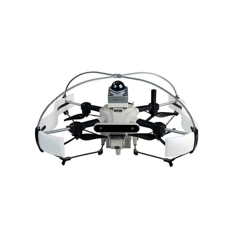
The SU17 is a compact and integrated research drone system built for high stability and robust performance.
By uniting the flight control unit, onboard processor, quad-vision SLAM camera setup, gimbal system, and data link into a streamlined structure, it ensures greater operational reliability.
Version:SU17
Type: Quadcopter
Take-off Weight:Approx. 2.3 kg (with protective cover and battery)
Diagonal Wheelbase:320 mm
Dimensions:442 mm (L) × 388 mm (W) × 174 mm (H) (without protective cover)
Maximum Payload:200 g
Wind Resistance:Level 4
SU17
The SU17 is a compact and integrated research drone system built for high stability and robust performance.
Specification
| Version | SU17 |
| Type | Quadcopter |
| Take-off Weight | Approx. 2.3 kg (with protective cover and battery) |
| Diagonal Wheelbase | 320 mm |
| Dimensions | 442 mm (L) × 388 mm (W) × 174 mm (H) (without protective cover) |
| Maximum Payload | 200 g |
| Hovering Endurance | Approx. 13 min (with air percentage, ≥0%) |
| 21 min with Visual Positioning (no LiDAR) | |
| Hovering Accuracy | GPS: ±1.5 m (V), ±2.0 m (H) |
| 3D LiDAR SLAM: ±0.08 m (V/H) | |
| Quad-Vision SLAM: ±0.05 m (V/H) | |
| Wind Resistance | Level 4 |
| Operating Temperature | -10°C ~ 40°C |
| Main MCU Chip | STM32H743 |
| IMU | ICM42688 / BMI088 |
| Barometer | MS5611 |
| Compass | QMC5883L |
| External Interface | USB (Type-C) |
| On-board Computer | |
| Processor | Intel Core i5-8365U |
| Memory Capacity | 8 GB |
| Memory Frequency | LPDDR3 @ 2133 MHz |
| Storage | 256 GB NVMe SSD |
| Ethernet Ports | 2 × 100 Mbps, 12V@3A, supports IEEE 1588-2008 (PTP v2) |
| Serial Ports | 2 × TTL, 5V/3.3V @ 500 mA |
| USB Ports | 2 × Type-C (1 × USB 2.0, 1 × USB 3.0) |
| HDMI | HDMI 1.4 |
| Power Battery | |
| Model | SU17-L |
| Type | High Voltage Lithium-ion Polymer Battery |
| Rated Voltage | 26.4V (Max), 21V (Min) |
| Storage Voltage | 22.8V (Typical) |
| Capacity | 6000 mAh |
| Weight | 680 g |
| Dimensions | 84.5 × 86.5 × 65 mm |
| Remote Controller | |
| Model | QE-2 |
| Number of Channels | 8 |
| Transmission Power | 18–20 dBm |
| Weight | 294.1 g |
| Gimbal | |
| Controllable Angle | -90° to +30° (Pitch Axis) |
| Streaming Type | RTSP (Commonly Used) |
| Encoding Format | H.264 |
| Resolution | 1080P @ 25fps |
| Diagonal FOV | 120° |
| Vertical FOV | 54° |
| Horizontal FOV | 95° |
| Data Transmission Module | |
| Operating Frequency Band | 2.4 GHz |
| Transmission Power | 18 dBm |
| Communication Range | 3 km (no interference) |
| 1 km (slight interference) | |
| Maximum Bandwidth | 40 Mbps |
Product Introduction
With support from its autonomous control software, SU17 enables intelligent features like object tracking, recognition, and autonomous route generation.
To enhance spatial awareness, it can be equipped with a Mid-360 3D LiDAR sensor and FAST-LIO algorithm for accurate 3D SLAM operations. Paired with EGO-Swarm algorithms, it excels at environmental mapping and live obstacle avoidance in dynamic or cluttered settings.
Purpose-built for scientific research and algorithm development, SU17 delivers superior adaptability and outstanding performance across experimental applications.
Product Details
High-Performance Drone Platform for Scientific Research
3D LiDAR: Real-time Mapping, Precise Navigation, and Obstacle Detection
Autonomous Toolkit: Pre-built demos for smooth system integration
Industrial-Grade Platform: Robust, modular, and tailored for experimental applications
It also provides interfaces for positioning data, flight modes, battery status, IMU, and other drone state and sensor data, along with position, velocity, acceleration, and attitude control interfaces, accompanied by usage examples.
Additionally, the drone is equipped with an onboard flight safety check function (non-obstacle avoidance) to enable automatic landing in abnormal situations, reducing crash risks and ensuring a safer development process.
Key features include gimbal and camera control, video recording and streaming, target detection, recognition, and tracking.
Users can issue commands like initial point hovering, current point hovering, landing, and position control with a single click.
Hardware-Software Framework
Hardware Framework
Software Framework
SU17 Software System Architecture Diagram
Hardware supports multi-sensor fusion of LiDAR, vision, and RTK
Open Grassland
Glass Corridor
Dark Corridor
Dense Forest
Low-light Tunnel
Underground Parking Garage
Structural Overview
Heat Dissipation Design
Integrated Structure Battery
Safety Design
Quick-Release Safety Guard Cover Design