Foxtech Provides Industrial Drone Solutions & UAV Payload Systems.
The purpose of FOXTECH HOBBY CO.,LIMITED is to deliver the high quality indoor drones for sale. From management to production, we are committed to excellence at all levels of operations. We have adopted an all-inclusive approach, from the design process to planning and materials procurement, developing, building and testing the product through to volume production. We make our efforts to produce the best quality product for our customers.
In the design of indoor drones for sale, FOXTECH HOBBY CO.,LIMITED makes full preparation including market survey. After the company makes an in-depth exploration in the customers' demands, innovation is implemented. The product is manufactured based on the criteria that quality comes first. And its lifetime is also extended to achieve a long-lasting performance.
We provide not only quality products like indoor drones for sale, but also excellent service. At Foxtech, your requirements for product customization, product sample-making, the MOQ of product, product delivery, etc. can be perfectly met.
Customer Background
A land management agency responsible for monitoring vast forest and grassland areas faced challenges with traditional inspection methods. Ground patrols were time-consuming and could not cover the expansive terrain efficiently, while aerial surveys using helicopters were costly and lacked the precision required for detailed mapping. The agency sought an efficient solution to not only monitor vegetation health and wildlife but also to create accurate topographical maps of large areas.
After reviewing several UAV options, the agency chose the Foxtech AYK Series VTOL, which offered a perfect combination of vertical takeoff and landing (VTOL) capability, long endurance, and high payload capacity for carrying the necessary equipment. The following advantages made it the ideal choice for forest and grassland inspection and mapping:
✈ VTOL Design – The ability to take off and land vertically means the drone can be deployed in dense forests and remote grassland areas without the need for runways.
✈ Thermal Imaging Capability – Equipped with a thermal imaging camera, the AYK Series can detect temperature variations in the environment, identifying areas of heat stress in vegetation or wildlife in need of tracking.
✈ High Payload Capacity – Supports LiDAR sensors, high-resolution optical cameras, and thermal cameras simultaneously, making it suitable for both inspection and mapping applications.
✈ Long-Endurance Flights – Capable of covering large areas in a single flight, reducing the need for frequent recharging and maximizing operational time.
✈ Autonomous Mapping and Inspection – The UAV uses RTK positioning for highly accurate aerial mapping and inspection, allowing for the creation of detailed 3D models and topographic maps.
✈ Equipment Integration – The AYK Series VTOL was equipped with LiDAR, thermal imaging cameras, and optical sensors for a comprehensive inspection and mapping solution.
✈ Flight Path Planning – Pre-programmed flight paths were set to cover the target areas efficiently, ensuring detailed data collection from multiple angles and altitudes.
✈ Automated Inspection & Mapping – The drone autonomously flew over the forest and grassland, capturing thermal images to identify hotspots and using LiDAR sensors to produce highly accurate topographic maps and 3D models.
✈ Data Processing and Output – The collected data was processed using advanced software to generate precise geographic mapping, helping the agency make informed land management decisions.
✈ Efficient Coverage – The AYK Series VTOL allowed the agency to inspect and map larger areas in a fraction of the time it would take with ground patrols or helicopters.
✈ Accurate Data for Decision-Making – The thermal imaging helped identify areas where vegetation was stressed or affected by disease, while LiDAR provided precise topographical maps for planning and development.
✈ Cost Savings – The long endurance and autonomous flight capability reduced the cost per mission by more than 50% compared to traditional aerial surveys.
✈ Enhanced Monitoring Capabilities – The real-time thermal data enabled faster detection of heat-related anomalies in the landscape, such as wildfires or animal activity, while 3D mapping provided a detailed overview of the terrain.
“The Foxtech AYK Series VTOL has greatly improved our efficiency in forest and grassland inspection and mapping. The combination of thermal imaging and LiDAR mapping allows us to create highly accurate topographic maps over large areas.This UAV has significantly reduced our operational costs and improved our decision-making process.” – Land Management Supervisor
The Foxtech AYK Series VTOL has greatly improved our efficiency in forest and grassland inspection and mapping. The combination of thermal imaging and LiDAR mapping allows us to create highly accurate topographic maps over large areas.
Looking to enhance your mapping and inspection efficiency?
Contact us today to learn how the AYK Series VTOL can optimize your land management and monitoring operations!
The 2025 World Drone Congress has just concluded, gathering top global enterprises, research institutions, and industry leaders. Drones are being applied across a wide range of fields, covering almost every sector.
Drones are evolving from “tools” to “intelligent ecosystems”
Penetrating All Industries
In the next five years,
With technological breakthroughs and improved policies,
Drones will reshape our lifestyles.
Are you ready?
According to data from the Civil Aviation Administration of China, over 1.875 million drones were registered nationwide in the first half of 2025, a year-on-year increase of 48%. Driven by both market demand and technological advancements, drones are becoming central to the low-altitude economy, and multidimensional application scenarios are reshaping industrial ecosystems through an “aerial revolution.”
Development Trends in Civil Drones
From agricultural protection and logistics delivery to emergency rescue, security, and patrol, the application scenarios of civil drones are expanding at an unprecedented speed.
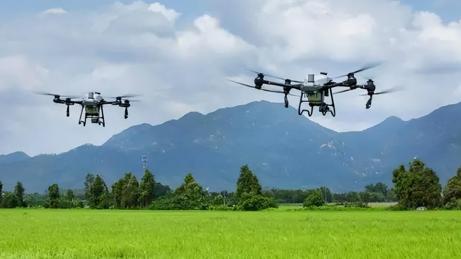
1. Agricultural Drones Advancing Toward “Full Automation”
In crop monitoring, drones equipped with sensors or cameras can monitor crop growth and detect pests and diseases in real time, assisting farmers in scientific field management. In plant protection, drones can carry pesticide tanks and spraying equipment to apply pesticides, fertilizers, or herbicides precisely, improving efficiency while reducing costs and labor.
Drone spraying ensures more uniform coverage of crops and enhances pest control effectiveness.
AI + precision agriculture enables drones equipped with multispectral sensors to monitor crop health in real time. Combined with AI algorithms, drones can automatically apply fertilizers and pesticides, increasing efficiency tenfold.
Drones can also be used for terrain mapping and land monitoring, providing reliable data for agricultural planning.
The agricultural drone market is expected to exceed USD 20 billion by 2030.
2. Logistics Drones Enter the “Minute-Level Delivery” Era
With many countries relaxing low-altitude flight restrictions, drones are being increasingly used in logistics, especially in remote or hard-to-reach areas. Drone logistics networks will enable fast and accurate delivery of small goods such as parcels and medicines, significantly improving logistics efficiency and reducing labor and vehicle costs.
Industry giants are racing to deploy: Amazon, JD.com, SF Express, and others are rapidly advancing drone delivery, with urban “15-minute delivery” expected by 2025.
3. Emergency Rescue Drones Become “Guardians of Life”
With the support of the drone technology ecosystem, China’s capabilities in disaster prevention, reduction, and relief have been significantly enhanced, enabling more efficient, safer, and smarter disaster management.
In complex terrains such as mountains, forests, and oceans, drones can search for missing persons and provide critical information to assist rescue operations.
Drones can also quickly deliver supplies and establish communication relays, playing a key role in disaster relief.
With rapid response to extreme weather and breakthroughs in swarm technology, multi-drone collaborative operations can achieve large-area search and rescue.
4. Security and Patrol
Drones can be used to patrol borderlines, detect intruders or suspicious activities, and ensure national security.
They can also monitor urban traffic and public safety in real time, providing strong support for city safety management.
Equipped with HD cameras and positioning systems, drones can autonomously patrol power grids, detect safety hazards, and transmit images in real time.
This greatly improves the efficiency and safety of power inspections, reducing injuries and power outages.
5. Environmental Monitoring and Protection
Drones, equipped with onboard sensors and high-definition cameras, can monitor environmental parameters such as air, water quality, and soil in real time, collecting high-resolution images and video data.
They can also locate and monitor pollution sources, providing accurate data to environmental authorities and supporting pollution control efforts.
6. Scientific Research and Education
– Scientific Research: Drones have wide applications in research fields such as atmospheric and ocean exploration, geological surveys, and archaeological excavations, enabling efficient data collection and sample retrieval.
– Aerial Education: In education, drones can be used for aerial teaching, such as geological fieldwork and natural landscape education.
HD images and video captured by drones allow students to intuitively understand natural phenomena and laws.
7. Other Civil Applications
– Sports Events: Drones can be used for live broadcasting and filming of sports events, enhancing the viewing experience.
– Advertising & Promotion: Drones can be used for aerial advertising and event shooting in promotional campaigns.
– Entertainment & Leisure: Drones are widely used in entertainment, such as model aircraft competitions and aerial shows.
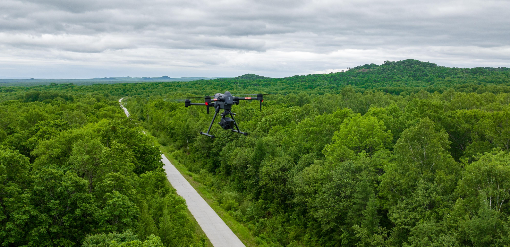
– Building Inspection: Drones can inspect buildings, bridges, and other infrastructure, improving work efficiency and safety.
– Aerial Photography & Filmmaking: Drones have a unique advantage in aerial photography, providing aerial images and footage for urban planning, land surveys, disaster assessment, tourism promotion, and the film/TV industry.
The International Civil Aviation Organization (ICAO) is promoting the development of drone air traffic management systems. With regulatory and technical upgrades progressing in parallel, safety has become a core concern. Anti-collision and countermeasure technologies are advancing rapidly.
Balancing innovation and regulation will remain a long-term issue for the industry.
As companies like EHang and XPeng accelerate the commercialization of passenger drones, cities like Dubai and Shenzhen have already launched pilot programs.
Urban Air Mobility (UAM) is moving from concept to reality, and over the next five years, UAM could give rise to a trillion-yuan market.
Human-machine technologies are evolving at an unprecedented pace, reshaping how we live, work, and interact with the world. From consumer aerial photography to industrial applications, from military reconnaissance to urban governance, drones are proving their unique value across diverse sectors. This article offers a comprehensive analysis of trends shaping the drone industry in 2025 and the years to come.
Global Market Overview
Market Size: The global drone market reached $33 billion in 2024
Growth Rate: CAGR maintained at 15–20%
Regional Distribution: North America 35%, Asia-Pacific 30%, Europe 25%, Others 10%
Growth Drivers: Technological advancement, cost reduction, expanded applications, policy support
Segment Analysis
Consumer Market: Maturing, growth slowing to ~10%
Commercial Market: Rapid growth at over 25%, key growth driver
Military Market: Stable at ~15% annual growth
Drone-as-a-Service (DaaS): Fast-growing model with over 30% annual growth
Key Industry Players
Consumer Drones: Dominated by DJI, with over 70% global market share; Autel, Skydio follow
Industrial Drones: Competitive landscape involving DJI, Parrot, Yuneec, Kespry
Military Drones: Led by General Atomics, Boeing, Lockheed Martin
Emerging Companies: Niche-focused innovators continue to emerge
China Market Highlights
Market Size: Reached approx. RMB 80 billion in 2024
Industry Clusters: The Pearl River Delta has become the world’s largest drone manufacturing base
Export Share: Over 60% of global drone exports come from China
Tech Level: Global leader in consumer drones; industrial/military sectors rapidly catching up
Industry Chain Analysis
Upstream: Increased domestic production of core components (flight controllers, motors, batteries)
Midstream: Scaled manufacturing with strong cost advantages
Downstream: Diversified service applications, rise of professional service providers
Supporting Services: Expanding ecosystems for training, insurance, repair
Policy Environment
Industrial Policies: Development action plans supporting drone manufacturing
Regulatory Framework: Gradual refinement of civil UAV management regulations
Airspace Reform: Steady progress in low-altitude airspace management reform
Standardization: Accelerated development of drone-related standards
Core Breakthroughs
Power Systems
Solid-State Batteries: 50% increase in energy density
Hydrogen Fuel Cells: 8–10 hours of flight time for long-endurance drones
Hybrid Power: Widely adopted in large drones
Solar Power: Efficient solar cells support high-altitude, long-endurance UAVs
Smart Control Systems
AI Flight Control: Deep learning integrated for better autonomous decision-making
Swarm Coordination: Single-operator, multi-drone collaboration now possible
Autonomous Navigation: Visual, inertial, and satellite navigation fused
All-Weather Capability: Improved stability in adverse conditions
Perception & Communication
Vision Systems: Computer vision enables human-like perception
Sensor Fusion: Integration of optical, infrared, LiDAR data
5G/6G Integration: Real-time data transmission with low latency
Satellite Connectivity: Global coverage for long-range UAVs
Materials & Manufacturing
Advanced Materials: Use of carbon fiber, graphene
Bionic Design: Bio-inspired flight mechanics
3D Printing: Rapid, lightweight, customized part production
Modular Design: Plug-and-play functionality
VTOL Fixed-Wing
Maturity: Combines vertical takeoff with efficient fixed-wing flight
Applications: Mapping, inspection, logistics
Performance: Improved payload, endurance, stability
Examples: WingtraOne Gen II, Quantum Trinity F90+
Hydrogen-Powered Drones
Breakthrough: Miniaturized, lightweight hydrogen systems
Advantages: Zero emissions, quick refueling, long endurance
Use Cases: Long-range inspection, mapping
Outlook: Rapid market growth post-2025
High-Altitude Pseudo Satellites
Definition: Solar-powered drones operating in the stratosphere
Features: Ultra-light, long-duration, autonomous
Use Cases: Communications relay, observation
Stage: Transitioning from testing to commercial use
Miniature & Bionic Drones
Micro-Scale: Palm-sized, pocket-sized drones
Bionics: Mimic birds and insects
Applications: Indoor inspection, tight-space detection, ecological monitoring
Challenges: Power, control systems, energy management
Upgrading Traditional Uses
Aerial Imaging
8K Video: Standard in high-end models
Computational Photography: Improved low-light, HDR with AI
Real-Time Editing: Onboard AI for live processing
Immersive Media: Integration with AR/VR
Mapping & Remote Sensing
Precision: Centimeter-level accuracy with RTK/PPK
Data Integration: Optical, LiDAR, multispectral fusion
Real-Time Modeling: Generate 3D maps during flight
Temporal Monitoring: Detect changes over time
Precision Agriculture
Variable Spraying: Cuts pesticide use by 30–50%
AI Pest Detection: Real-time identification and targeting
Fully Autonomous: Hands-free operation
Data Analytics: Farm health monitoring based on historical data
Efficient Inspection
AI Defect Detection: Power lines, pipelines
Thermal Imaging: Detect anomalies early
All-Weather Capabilities
Data Management: Automated analysis and reporting
Urban Air Mobility (UAM)
eVTOL Aircraft: Commercial passenger drones launching
Air Taxi Services: Pilot projects in cities
Infrastructure: Vertiports, charging stations in development
Regulation: UTM frameworks emerging
Drone Delivery
Last-Mile: Active commercial services
Trunk Logistics: Large drones link distribution hubs
Emergency Supplies: Normalized in disasters, remote areas
Cold Chain: Transport for pharma, perishables
Environmental Monitoring
Air Quality: Monitor pollutants and greenhouse gases
Water Monitoring: Real-time data collection
Biodiversity: Wildlife and habitat assessments
Carbon Monitoring: Evaluate carbon sinks
Emergency Response
Disaster Assessment
Search & Rescue: AI + thermal imaging
Communication Support
Firefighting Assistance
Digital Twin Cities
High-Precision Modeling
Real-Time Updates
Multi-Sensor Awareness
Use Cases: Planning, traffic, emergency response
Smart Agriculture
Full Lifecycle Monitoring
Precision Farming
Yield Forecasting
Agri-Insurance
Cultural & Creative Industries
Aerial Filmmaking
Drone Light Shows
Heritage Preservation
Immersive Tourism
Scientific Research
Polar Expeditions
Volcano Studies
Atmospheric Science
Marine Monitoring
Supply Chain Evolution
Component Localization: Domestic production of critical parts
Professionalization: Vertical specialization and collaboration
Cluster Development: Pearl River Delta, Yangtze Delta, Beijing-Tianjin-Hebei
International Competition: Trade barriers, standards, and cooperation
Business Model Innovation
Drone-as-a-Service (DaaS): Subscription-based services replacing hardware sales
Vertical Solutions: Industry-specific packages
Data Monetization: Shifting value to data services
Ecosystem Building: Developer tools, app stores, data markets
Finance & Insurance
Leasing: Popular for high-end drones
Insurance: Specialized policies growing
Risk Management: Predictive analytics based on flight data
Innovation: Asset securitization
Talent Development
Skill Needs: AI, flight control, sensors, data analysis
Training Pathways: Academic, vocational, enterprise, and online programs
International Talent Competition: Cross-border collaboration and mobility
Global Trends
USA: Remote ID, BVLOS approvals, UTM rollout
EU: Unified registration and certification system
Asia-Pacific: China leading airspace reform; Japan, Singapore fostering innovation
International Coordination: ICAO frameworks, standard recognition, airspace agreements
China Outlook
Airspace Reform: Tiered low-altitude airspace management
Regulatory Framework: Risk-based management, operator licensing, mandatory insurance
Policy Support: R&D subsidies, application pilots, standards development
Privacy & Security: Data protection, anti-drone systems, risk assessments
Energy & Endurance
Barriers: Battery limits, short flight time
Solutions: Solid-state and hydrogen fuel cells, solar supplements, smart power management
All-Weather Performance
Barriers: Reliability in rain, wind, lightning
Solutions: IP67 waterproofing, anti-icing, wind resistance, lightning protection
Autonomous Intelligence
Barriers: Limited perception and decision-making
Solutions: Edge AI, sensor fusion, reinforcement learning, knowledge graphs
Communication & Control
Barriers: Long-range, anti-interference needs
Solutions: Spectrum optimization, encryption, 5G/satellite integration, autonomous fallback
Safety Risks
Flight Risks: Collision, loss of control
Mitigation: Redundancy, predictive maintenance, fail-safe design, full-range obstacle avoidance
Cybersecurity
Threats: Data theft, control hijacking, GPS spoofing
Solutions: End-to-end encryption, secure chips, anomaly detection, cross-referenced navigation
Counter-Drone Systems
Detection: Radar, optical, RF, acoustic
Interference: Jamming, spoofing
Interception: Net launchers, lasers, kinetic
Integrated Defense: Multi-layered systems
2025–2030 Forecast
Tech Maturity: Autonomous AI, new energy, 6G networks
Applications: UAM, drone logistics, infrastructure, public services
Market Scale: $100+ billion global market
Social Impact: New work/life modes, environmental gains, privacy/safety adaptation
2030–2035 Vision
Disruptive Tech: Quantum comms, bionics, self-healing materials, brain-machine control
Deep Integration: Digital twins, metaverse, smart cities, space missions
Ecosystem Evolution: Platforms dominate, cross-sector fusion, global governance
Societal Shift: Low-altitude space as the next frontier, tech ethics advance
Business Strategy
Tech Focus: AI, energy, materials
Differentiation: Avoid homogeneity
Balance: Openness vs proprietary tech
Foresight: Bet on emerging paths
Model Transformation
Service-First: From selling drones to delivering outcomes
Vertical Specialization
Data Value: Monetize drone data
Partnerships: Build ecosystems
Globalization
Localization: Regulatory and cultural fit
Compliance: Anticipate global safety/privacy rules
Cooperation: Joint ventures, licensing
Brand Building: Global trust and presence
Risk Management
Tech Risk: Dependency and bottlenecks
Market Risk: Volatility, competition
Policy Risk: Regulatory shifts
IP Risk: Protection and litigation readiness
Investor Priorities
Hot Sectors: AI flight control, vertical applications, DaaS
Risk Evaluation: Tech, policy, market, team
Exit Strategy: IPOs, M&A, timing
Long-Term Value: Moats, data, platforms
Talent Development
Skills: Algorithms, sensors, applications
Career Paths: Technical, application, management, entrepreneurship
Learning: Academic, vocational, online, practical
Communities: Open-source, associations, workshops
Conclusion
Drone technology is shifting from rapid development to deep integration. The next decade will see widespread use of AI, new energy, and advanced materials, reshaping global industries and daily life. A market surpassing $100 billion, the rise of urban air mobility, and service-based business models signal a new era.
To stay competitive, players must focus on core technologies, specialize in verticals, build ecosystems, and stay agile amid evolving regulations. As drones reshape society, it's vital to address safety, privacy, and ethics—ensuring this powerful technology truly benefits humanity.
Wireless video transmitters for cameras have revolutionized the way photographers and videographers capture and transmit footage. These devices make it possible to send high-quality video signals wirelessly to monitors, receivers, or other devices in real-time. However, with a multitude of options available on the market, choosing the right wireless video transmitter for your camera can be a daunting task. In this article, we will explore the key factors to consider when selecting a wireless video transmitter, helping you make an informed decision.
Compatibility
When choosing a wireless video transmitter for your camera, compatibility is a crucial factor to consider. You need to ensure that the transmitter you select is compatible with your camera model and any other devices you intend to use it with. Some transmitters are designed to work with specific camera brands or models, while others offer a more universal compatibility. It's essential to check the specifications of the transmitter and make sure it supports the resolutions and frame rates of your camera.
Moreover, consider the type of connections your camera and other devices have. Some transmitters offer HDMI inputs, while others support SDI or composite connections. Make sure the transmitter you choose has the necessary input and output ports to connect seamlessly with your camera and other equipment.
In addition to compatibility with your camera, consider the range and signal strength of the transmitter. Depending on your shooting requirements, you may need a transmitter with a longer range to transmit signals over greater distances. Look for transmitters that offer reliable connectivity and minimal signal interference to ensure smooth and uninterrupted transmission.
Video Quality and Latency
Another critical factor to consider when choosing a wireless video transmitter is the video quality it can deliver and the latency it introduces. The video quality of the transmitter should match the resolution and frame rate capabilities of your camera to ensure that you capture and transmit high-quality footage.
Latency, or the delay between the time an image is captured by the camera and when it is displayed on the receiving device, is also important to consider. Low latency is essential for live monitoring and ensuring that you can react quickly to changing situations. Look for transmitters that offer minimal latency to provide a real-time viewing experience.
When assessing the video quality and latency of a wireless video transmitter, consider factors such as compression technology, signal processing, and transmission protocols. Some transmitters use advanced compression algorithms to reduce bandwidth requirements without compromising video quality, while others offer low-latency transmission for real-time monitoring. Evaluate these features to choose a transmitter that meets your specific needs.
Portability and Ease of Use
Portability and ease of use are essential considerations when selecting a wireless video transmitter for your camera. Whether you're shooting on location or in a studio, you need a transmitter that is compact, lightweight, and easy to set up.
Look for transmitters that are designed for mobility and offer convenient mounting options for attaching to your camera or rig. Consider the power source of the transmitter, as some models are powered by batteries, while others require an external power supply. A portable transmitter with long battery life can be a practical choice for extended shooting sessions.
Furthermore, consider the user interface and control options of the transmitter. A user-friendly interface with intuitive controls makes it easier to adjust settings, monitor signal strength, and troubleshoot any issues that may arise. Look for transmitters that offer remote control capabilities via smartphone apps or dedicated controllers for added convenience.
Interference and Signal Range
Interference and signal range are critical factors to consider when choosing a wireless video transmitter for your camera. Interference can cause signal disruptions, dropouts, or degraded video quality, compromising the overall transmission reliability.
Look for transmitters that operate on multiple frequency bands or offer advanced signal processing techniques to minimize interference from other wireless devices or environmental factors. Some transmitters use adaptive frequency hopping or encryption protocols to maintain a stable connection and prevent signal interference.
In addition to interference, consider the signal range of the transmitter. Depending on your shooting requirements, you may need a transmitter that can transmit signals over long distances without losing quality. Look for transmitters with a sufficient range to cover the distance between your camera and receiving device, ensuring a reliable and stable connection.
Price and Budget
When choosing a wireless video transmitter for your camera, price and budget are important considerations. The cost of wireless transmitters can vary significantly based on features, brand reputation, and technical specifications.
Set a budget for your wireless video transmitter based on your shooting needs and equipment requirements. Consider whether you need additional features such as multiple input/output ports, remote monitoring capabilities, or advanced signal processing. Evaluate different transmitter models and compare prices to find a device that offers the best value for your budget.
Keep in mind that investing in a high-quality wireless video transmitter is crucial for achieving professional-quality video production. While budget-friendly options are available, prioritize reliability, performance, and compatibility with your camera and other devices when making a purchase decision.
In conclusion, selecting the right wireless video transmitter for your camera involves considering factors such as compatibility, video quality, latency, portability, interference, signal range, and price. By evaluating these key factors and understanding your specific shooting requirements, you can choose a transmitter that meets your needs and helps you capture high-quality footage seamlessly. Whether you're shooting on location, in a studio, or on the move, a reliable wireless video transmitter is a valuable tool for enhancing your video production workflow.
Drones have become increasingly popular in various industries, from photography and videography to agriculture and search and rescue missions. One of the key features drone operators look for is a reliable long-range video transmitter. This essential component allows real-time video footage to be transmitted from the drone to the controller, giving operators a clear view of what the drone sees. With so many long-range video transmitters on the market, it can be challenging to determine which one works best for drones. In this article, we will explore some of the top long-range video transmitters available and compare their features to help you make an informed decision.
Amimon Connex Mini
The Amimon Connex Mini is a popular choice among drone enthusiasts for its reliable long-range video transmission capabilities. This transmitter operates on the 5.8GHz frequency band and offers a range of up to 1,600 feet, making it ideal for capturing footage from a distance. The Connex Mini provides high-definition video transmission with zero latency, ensuring smooth and clear footage in real-time. Additionally, it features a robust signal that can penetrate obstacles such as trees and buildings, maintaining a stable connection between the drone and the controller.
One of the standout features of the Amimon Connex Mini is its lightweight and compact design, making it easy to install on various drone models without adding unnecessary bulk. The transmitter is also user-friendly, with simple plug-and-play functionality that allows for quick setup and seamless integration with your existing drone equipment. Whether you're a professional aerial photographer or a hobbyist looking to capture stunning aerial footage, the Amimon Connex Mini is a reliable choice for long-range video transmission.
Teradek Bolt 500
Another top contender in the long-range video transmitter market is the Teradek Bolt 500. This transmitter offers a range of up to 500 feet and operates on the 5GHz frequency band, providing a stable and interference-free connection for high-quality video transmission. The Bolt 500 is equipped with an HDMI input and output, allowing for seamless integration with various cameras and monitors for a customized video setup.
One of the key advantages of the Teradek Bolt 500 is its compact and lightweight design, making it easy to mount on drones without affecting their performance or maneuverability. The transmitter also features a robust signal that can penetrate obstacles, ensuring a reliable connection between the drone and the controller even in challenging environments. Whether you're capturing action-packed footage or conducting aerial surveys, the Teradek Bolt 500 is a versatile and reliable choice for long-range video transmission.
Paralinx Tomahawk
The Paralinx Tomahawk is a top-of-the-line long-range video transmitter designed for professional drone operators who demand the best in performance and reliability. This transmitter offers an impressive range of up to 2,000 feet and operates on the 5GHz frequency band, providing a clear and stable connection for high-definition video transmission. The Tomahawk is equipped with multiple antennas for enhanced signal strength and diversity, ensuring consistent and uninterrupted video feed from the drone to the controller.
One of the standout features of the Paralinx Tomahawk is its low latency transmission, allowing for real-time monitoring and control of the drone without any delays. The transmitter is also compatible with various cameras and monitors, making it easy to integrate into your existing drone setup. Whether you're filming aerial footage for a movie production or conducting precision mapping missions, the Paralinx Tomahawk delivers unmatched performance and reliability for long-range video transmission.
Connex Fusion
The Connex Fusion is a cutting-edge long-range video transmitter designed for professional aerial filmmakers and cinematographers who demand the highest quality in video transmission. This transmitter offers a range of up to 1,000 feet and operates on the 5.8GHz frequency band, providing a clear and reliable connection for streaming 4K video footage from the drone to the controller. The Fusion is equipped with advanced signal processing technology that ensures stable and interference-free transmission, even in crowded environments.
One of the key advantages of the Connex Fusion is its seamless integration with professional camera systems, allowing for comprehensive camera control and real-time video monitoring. The transmitter also features a compact and lightweight design, making it easy to mount on various drone models without affecting their performance or flight characteristics. Whether you're capturing cinematic aerial shots or conducting live broadcasts from the sky, the Connex Fusion delivers unparalleled performance and quality for long-range video transmission.
Ghost-Eye 150M
The Ghost-Eye 150M is a versatile long-range video transmitter designed for drone operators who require reliable video transmission in high-traffic environments. This transmitter offers a range of up to 500 feet and operates on the 5GHz frequency band, providing a clear and stable connection for streaming live video footage from the drone to the controller. The Ghost-Eye 150M is equipped with multiple channels and antennas for enhanced signal strength and diversity, ensuring uninterrupted video feed even in challenging wireless conditions.
One of the standout features of the Ghost-Eye 150M is its compact and portable design, making it easy to carry and set up for on-the-go filming missions. The transmitter is also compatible with a wide range of cameras and monitors, allowing for flexible integration with different drone setups. Whether you're documenting outdoor events or conducting aerial inspections, the Ghost-Eye 150M offers reliable performance and quality for long-range video transmission.
In summary, choosing the right long-range video transmitter for your drone is crucial for capturing high-quality aerial footage and maintaining a stable connection between the drone and the controller. Each of the transmitters mentioned in this article offers unique features and benefits, catering to different needs and preferences of drone operators. Whether you prioritize range, signal strength, low latency, or compatibility with your existing equipment, there is a long-range video transmitter that will suit your specific requirements. By considering the features and capabilities of each transmitter, you can make an informed decision and enhance your drone's performance for various aerial applications.